
The above chart (click to enlarge) is an extract of the small scale CHS navigation chart for the Queen Charlotte Islands, Central and North coast of BC and Hecate Strait. The red lines bordering the coast of each landmass indicates the limits of pilotage waters in which large ships must have a licensed BC Coast Pilot onboard. That is to say, when in Hecate Strait facing the mainland of BC, pilotage waters are to the east of the easternmost red line. Facing the Queen Charlotte Islands, pilotage waters are to the west of the westernmost red line.
Unlike the waters around southern Vancouver Island and the south BC coast generally, none of the sea areas, inlets, arms, passages or any other tidal waters area or port have coastal radar coverage intended to monitor or aid marine traffic. In fact, there is not even a traffic separation scheme intended to prevent the interaction of ships in the restricted waters of the inside passage.
Let's now take a closer look at a particular area in question.
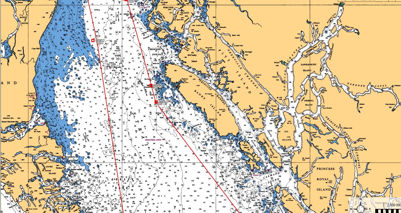
This is simply a larger scale extract of the Hecate Strait CHS chart. (Click to enlarge). You can see the type of difficulty a ship approaching the coast would encounter. For one thing Hecate Strait is world renown for being one nasty stretch of water and boarding a pilot during periods when gale to hurricane force winds are ripping up the place will be anywhere from extremely difficult to life threatening. Additionally, in periods of high winds and high seas, many of the ships expected to approach the coast will encounter a problem developing enough propulsion power to avoid being pushed further shoreward and into some very dangerous shoal ground.

The above is an example of the actual surface weather on 2 April 2012: A mid-latitude depression with an incredible 958 millibar low pressure centre just off the west coast of the Queen Charlotte Islands. Forecast winds north of Vancouver Island and into Hecate Strait were South East at Hurricane Force throughout the morning with seas exceeding 8 meters. With a surface picture like the one above it would constitute a herculean effort for an inbound ship in ballast to maintain adequate control to reach shelter and safe waters. An outbound laden vessel, depending on its size, could easily be set to the north and, if it was exiting Caamano Sound, find itself slamming headlong into the southern extremities of the Queen Charlotte Islands.
There has been much discussion that, in the absence of suitable shore-based radar, the current Automatic Information System (AIS) will provide accurate data on the position, course and speed of any ship in the approaches to either Browning Entrance or Caamano Sound. That would be a temporary fix only. AIS, as useful as it is, is not accurate real-time tracking. Further, it has serious flaws, not the least of which is that vessels often drop off the AIS plot depending on where they are in relation to LOS blocking land masses.

The above is an AIS collection shot. Remarkably, what is missing from this capture is the traffic that was actually present in the inside passages of the central BC coast (3 vessels) and one making a transit across Hecate Strait.
None of this is to say that the Northern Gateway pipeline terminal to Kitimat should or should not proceed. That is not the purpose for now.
It is to point out that the means to ensure complete tanker safety under pilotage and secure vessel traffic management do not yet exist and the recent federal budget is less than comforting.
As pointed out in a previous submission the federal government had this one opportunity to fund and start implementing the required changes to the BC north and central coast to bring shipping safety to a level which will satisfy the need to increase safety and oversight of a massive increase in heavy ship traffic.
The federal government not only did not do anything, it actually cut the budget of the one department responsible for upgrading the vessel traffic services in the critical area. As has been pointed out previously, Enbridge which originally stated that they would be installing new VTS radar and nav aids has made it clear that they have no intention of bearing the cost and are negotiating with the federal government.
None of this is aided by the offerings of Enbridge. This disingenuous bit of propaganda needs to be addressed.
At the link above, Enbridge provides a picture of a chemical tanker arriving in Kitimat on 16 March 2012, and then goes on to provide numbers which demonstrate a continuous flow of tankers between 1982 and 2009, and why don't all you environmental activists just chew on all those wonderful facts.
Well, since I commanded a chemical tanker into the port of Kitimat, I suppose I should clear up some of the fog which the Enbridge spin-merchant has dumped.
Chemical tankers are considerably smaller than the ships Enbridge is proposing to bring to Kitimat. Most chemical tankers max out at about 40,000 DWT.
Enbridge is proposing the following size ships:
AFRAMAX - 120,000 DWT
SUEZMAX - 200,000 DWT
VLCC - 315,000 DWT (eight times the size of a large chemical tanker)
Enbridge, in playing with their numbers (which are accurate) did not provide the annual average numbers. Between 1982 and 2009 there was actually an average of 55 transits of Douglas Channel by tankers annually - somewhere around one ship per week.
Enbridge plans to increase that to about 220 annually, or about 4 to 5 ships per week. And the ships they plan on introducing will be anywhere from three times to eight times the size of existing ships.
Another point, conveniently side-stepped, is that with three LNG terminals in the works at Kitimat, the traffic into Kitimat will actually increase by much more than 220 ships per year. Somewhere on the scale of 400 is much more likely once all terminals are running at capacity.
Enbridge tries to downplay the cargo by suggesting that the current shipping traffic is carrying petroleum products, therefore they are not introducing anything new. Except that they are.
Current and past product into and out of Kitimat was mostly methanol and condensate. Petroleum products they are, but they are actually highly evaporative liquid by-products of natural gas. A spill would cause some immediate damage to be sure, but it would evaporate in short order and there would be little in the way of a persistent effect.
What Enbridge is proposing, (and what they are attempting to favourably compare to a highly evaporative liquid), is actually a liquefied, unrefined, thick crude oil, much more akin to tar than it is to methanol. A spill of that type of product would create lasting devastation for decades - if you could ever get it cleaned up at all.
That brings up the cost of a clean-up, should it ever be required. There is a long and winding road to travel to get both the funding and the resources to deal with a spill. Insurance is a tricky game in the shipping world.
We'll take a look at that next time.
13 comments:
Those dirty tar tankers are massive, and have to make hairpin turns. Just yesterday, the wind tore siding off my house. There are hurricane force wind warnings every other day.
Recently there were three freighters, that were caught in one of the bad storms off the coast of Northern BC. The storm tore off the top load of their logs. The ship put in a distress call. They were afraid, if the bottom load of logs shifted, the ship could capsize. It took literally hours, to reach the stricken ship. The other two freighters, also had the storm tear their cargo off into the sea. They managed to limp into BC harbors. There were rogue waves, 70 feet high.
The Enbridge pipeline is also very stupid. There are avalanches, mudslides, rock slides, earthquakes and swift running flooded rivers, that wipe out highways and homes. How in the hell will they get through 15 feet of snow, to reach the pipe burst? Mind you, Enbridge doesn't bother to clean up their disasters, as they didn't clean up their spill in the Kalamazoo River. Enbridge just had another spill, ten miles from their Kalamazoo spill. Enbridge just puts sand on top of the dirty oil, and then plants grass. Stick your shovel into the sand, and you strike oil.
Thank you for presenting this series of facts regarding the perils of navigation on the west coast and the regulations surrounding them. Facts should outweigh spin at the hearings but it remains to be seen if these facts will be presented and taken into account.
as with the proposed pipeline it is clear that should this project proceed it is a case of WHEN a spill will take place not IF and what resources are in place to deal with it and the impact such spill will have. The risk is unacceptable IMHO.
I don't know where I would learn this if not for you. I am a land-lubber and I have never been on those waters. When the former GreenPeace/current Enbridge shill was in town he told an audience that it was a straight shot from Kitimat to Hecate Straite. It sure does not look like a straight shot to me, it looks like there are a lot of corners and little islands to navigate around. My boss, who likes to ocean fish in those waters says he too thinks it is a straight shot. Is my boss only thinking of tiny little boats or is he nuts? The other guy is paid to say things, so I take him with a block of salt. I'm not in favour of that pipeline or more tankers and I hope to be able to tell the Joint Panel Review so in July, but this conversation with my boss bugs me.
I really, really appreciate the information you are posting here. Are you speaking to the JPR?
It is not a straight shot to Hecate Strait from Kitimat Arm. It's not even close.
What many may also not be aware of is that BC Coast Pilots require ships entering through Caamano Sound to be able to maintain a minimum speed of 14.5 knots. That's just nuts.
I have a professional submission to the JRP but will not be appearing.
Thank you again.
A well researched expository on the subject and the first that I have seen not simply based on reactionary sentiment.
It is clear that there must be significant preparation and planning before anything of this magnitude is attempted on our North coast. It is also clear that for whatever reason our own government and regulatory bodies have not adequately established the necessary groundwork for what is being proposed.
If Kitimat is to be opened to larger ships and increased traffic our DOF must take a proactive role in preparing the region. It is deeply disturbing that they are not being given the funding to enable safe shipping.
Through my work on a freighter on the East Coast I have directly dealt with shipping in areas that are not well covered by a proper VTS. In Trinity Bay a "pseudo-VTS" has been established by one of these oil and gas companies and the results would be laughable if they weren't so concerning. As part of their deal with the Province of Newfoundland this particular company promised to establish traffic monitoring; the reality is that the system exists largely on paper as they do not monitor their own radio frequency.
It seems like a no-brainer that the infrastructure should be in place before any large ship ever plies those waters. However, it is also clear that the responsibility cannot lie with the oil company as the stakes are too high.
While I am not against tanker traffic in the region outright it is clear to me that there is cause for pause.
Tidal Station,
I note you have a professional submission to the JRP. Are you a registered intervenor, or have you submitted a letter of comment?
As a registered intervenor myself, I'd sure like to read what you've put to the JRP since it's definitely in my area of interest.
Would you please steer me to a link so that I can see your submission to the JRP.
We Say No, My comments should be a part of the OCIMF submission of several months ago.
Thanks for your great work on this item. As a Master Mariner myself you have said it all for me. I did write a open letter to the Vancouver Observer which was published saying in brief what you have detailed here and I did it prior to finding out about this blog site. I salute you , great work keep it coming.
I need some advice from you or someone with similar qualifications, to help with prep for the Joint Review Panel. Would you be prepared to assist by email? kwristen@livingoceans.org
Thank you so much for writing these posts. They're extremely informative and I know it must have taken quite a bit of time.
thank you for your analysis of information being deliberately concealed by the fraudulent coalition/collusion between corporate welfare recipients and the federal government
from a non-professional surface examination of the coastline it seems obvious that Prince Rupert would be a much more sensible choice for a multiple-pipeline terminus since it is close to open ocean without a long transit through narrow treacherous channels
why Kitimat instead of Prince Rupert ?
Post a Comment