
The above chart (click to enlarge) is an extract of the small scale CHS navigation chart for the Queen Charlotte Islands, Central and North coast of BC and Hecate Strait. The red lines bordering the coast of each landmass indicates the limits of pilotage waters in which large ships must have a licensed BC Coast Pilot onboard. That is to say, when in Hecate Strait facing the mainland of BC, pilotage waters are to the east of the easternmost red line. Facing the Queen Charlotte Islands, pilotage waters are to the west of the westernmost red line.
Unlike the waters around southern Vancouver Island and the south BC coast generally, none of the sea areas, inlets, arms, passages or any other tidal waters area or port have coastal radar coverage intended to monitor or aid marine traffic. In fact, there is not even a traffic separation scheme intended to prevent the interaction of ships in the restricted waters of the inside passage.
Let's now take a closer look at a particular area in question.
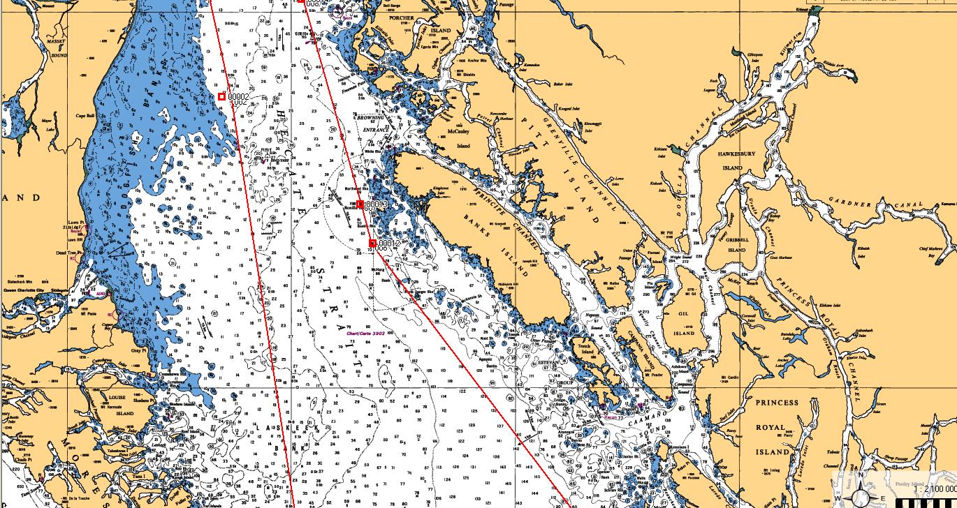
This is simply a larger scale extract of the Hecate Strait CHS chart. (Click to enlarge). You can see the type of difficulty a ship approaching the coast would encounter. For one thing Hecate Strait is world renown for being one nasty stretch of water and boarding a pilot during periods when gale to hurricane force winds are ripping up the place will be anywhere from extremely difficult to life threatening. Additionally, in periods of high winds and high seas, many of the ships expected to approach the coast will encounter a problem developing enough propulsion power to avoid being pushed further shoreward and into some very dangerous shoal ground.

The above is an example of the actual surface weather on 2 April 2012: A mid-latitude depression with an incredible 958 millibar low pressure centre just off the west coast of the Queen Charlotte Islands. Forecast winds north of Vancouver Island and into Hecate Strait were South East at Hurricane Force throughout the morning with seas exceeding 8 meters. With a surface picture like the one above it would constitute a herculean effort for an inbound ship in ballast to maintain adequate control to reach shelter and safe waters. An outbound laden vessel, depending on its size, could easily be set to the north and, if it was exiting Caamano Sound, find itself slamming headlong into the southern extremities of the Queen Charlotte Islands.
There has been much discussion that, in the absence of suitable shore-based radar, the current Automatic Information System (AIS) will provide accurate data on the position, course and speed of any ship in the approaches to either Browning Entrance or Caamano Sound. That would be a temporary fix only. AIS, as useful as it is, is not accurate real-time tracking. Further, it has serious flaws, not the least of which is that vessels often drop off the AIS plot depending on where they are in relation to LOS blocking land masses.

The above is an AIS collection shot. Remarkably, what is missing from this capture is the traffic that was actually present in the inside passages of the central BC coast (3 vessels) and one making a transit across Hecate Strait.
None of this is to say that the Northern Gateway pipeline terminal to Kitimat should or should not proceed. That is not the purpose for now.
It is to point out that the means to ensure complete tanker safety under pilotage and secure vessel traffic management do not yet exist and the recent federal budget is less than comforting.
As pointed out in a previous submission the federal government had this one opportunity to fund and start implementing the required changes to the BC north and central coast to bring shipping safety to a level which will satisfy the need to increase safety and oversight of a massive increase in heavy ship traffic.
The federal government not only did not do anything, it actually cut the budget of the one department responsible for upgrading the vessel traffic services in the critical area. As has been pointed out previously, Enbridge which originally stated that they would be installing new VTS radar and nav aids has made it clear that they have no intention of bearing the cost and are negotiating with the federal government.
None of this is aided by the offerings of Enbridge. This disingenuous bit of propaganda needs to be addressed.
At the link above, Enbridge provides a picture of a chemical tanker arriving in Kitimat on 16 March 2012, and then goes on to provide numbers which demonstrate a continuous flow of tankers between 1982 and 2009, and why don't all you environmental activists just chew on all those wonderful facts.
Well, since I commanded a chemical tanker into the port of Kitimat, I suppose I should clear up some of the fog which the Enbridge spin-merchant has dumped.
Chemical tankers are considerably smaller than the ships Enbridge is proposing to bring to Kitimat. Most chemical tankers max out at about 40,000 DWT.
Enbridge is proposing the following size ships:
AFRAMAX - 120,000 DWT
SUEZMAX - 200,000 DWT
VLCC - 315,000 DWT (eight times the size of a large chemical tanker)
Enbridge, in playing with their numbers (which are accurate) did not provide the annual average numbers. Between 1982 and 2009 there was actually an average of 55 transits of Douglas Channel by tankers annually - somewhere around one ship per week.
Enbridge plans to increase that to about 220 annually, or about 4 to 5 ships per week. And the ships they plan on introducing will be anywhere from three times to eight times the size of existing ships.
Another point, conveniently side-stepped, is that with three LNG terminals in the works at Kitimat, the traffic into Kitimat will actually increase by much more than 220 ships per year. Somewhere on the scale of 400 is much more likely once all terminals are running at capacity.
Enbridge tries to downplay the cargo by suggesting that the current shipping traffic is carrying petroleum products, therefore they are not introducing anything new. Except that they are.
Current and past product into and out of Kitimat was mostly methanol and condensate. Petroleum products they are, but they are actually highly evaporative liquid by-products of natural gas. A spill would cause some immediate damage to be sure, but it would evaporate in short order and there would be little in the way of a persistent effect.
What Enbridge is proposing, (and what they are attempting to favourably compare to a highly evaporative liquid), is actually a liquefied, unrefined, thick crude oil, much more akin to tar than it is to methanol. A spill of that type of product would create lasting devastation for decades - if you could ever get it cleaned up at all.
That brings up the cost of a clean-up, should it ever be required. There is a long and winding road to travel to get both the funding and the resources to deal with a spill. Insurance is a tricky game in the shipping world.
We'll take a look at that next time.